Roaming About

A Life Less Ordinary

Category: Gallery (page 1 of 10)

Two Otherworldly Highlights in Bolivia – Salar de Uyuni & Valle de las Rocas

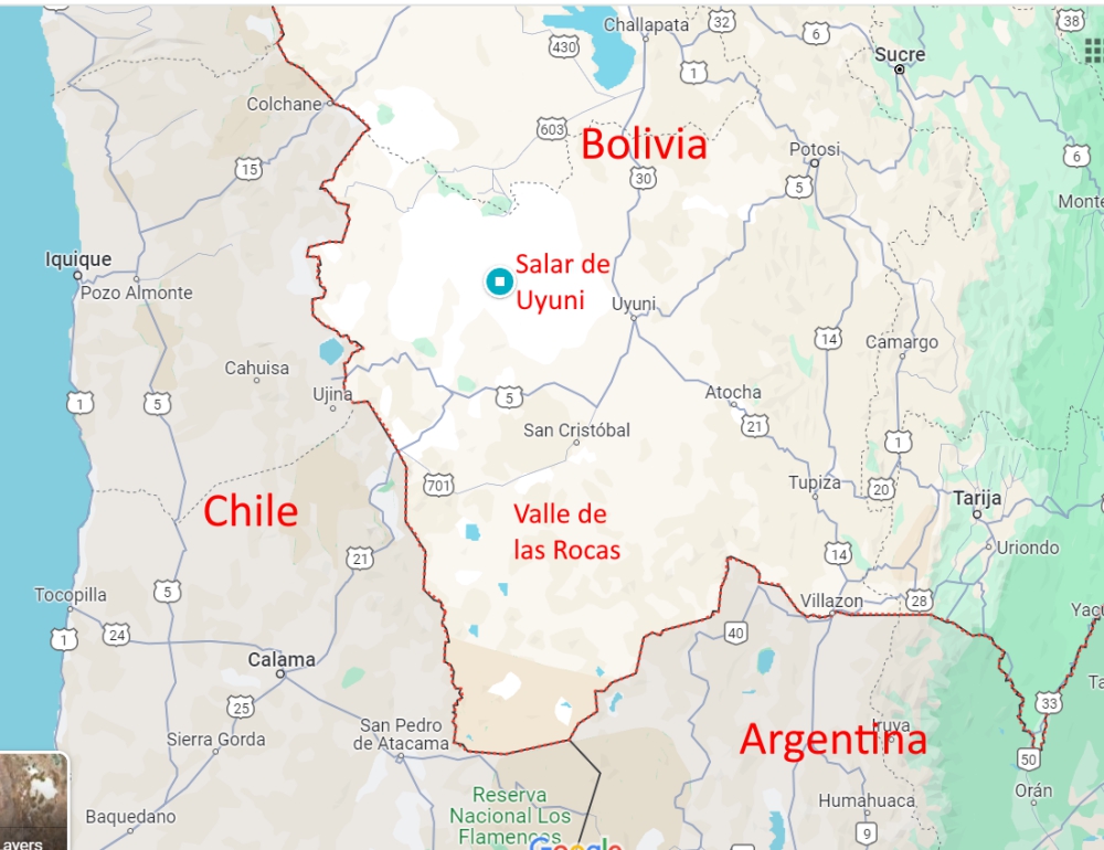
Salar & Valle de las Rocas in Bolivia

Salar de Uyuni

Salar de Uyuni – or Salar de Tunupa (the local Quechua people prefer to call the area by its original name) – is located 20 minutes north of Uyuni and is the largest salt flat in the world. It measures 12,000 km2, which, to put it in perspective, is a bit over 1/3 the size of Belgium and four times the surface of Luxembourg. For Americans, Rhode Island fits three times into this Salar and Delaware twice – and New Jersey is twice as big.

(As always, click on or hover over photos in galleries to read their captions.)

Many overlanders prefer to drive and camp on this white, vast surface, usually stopping when they can’t see anything but salt around them. A trip on the salt flat with your own vehicle offers a lot of freedom, solitude, and fun, but it also requires protecting the undercarriage from all that destructive salt and giving it a detailed and thorough cleaning in the end. In the dry season. Once the wet season has started in Bolivia, taking your own home on wheels is a bad idea, because the (wet) salt will get anywhere and destroy everything it touches, over time. Plus, some parts of this area are closed when (too) wet.

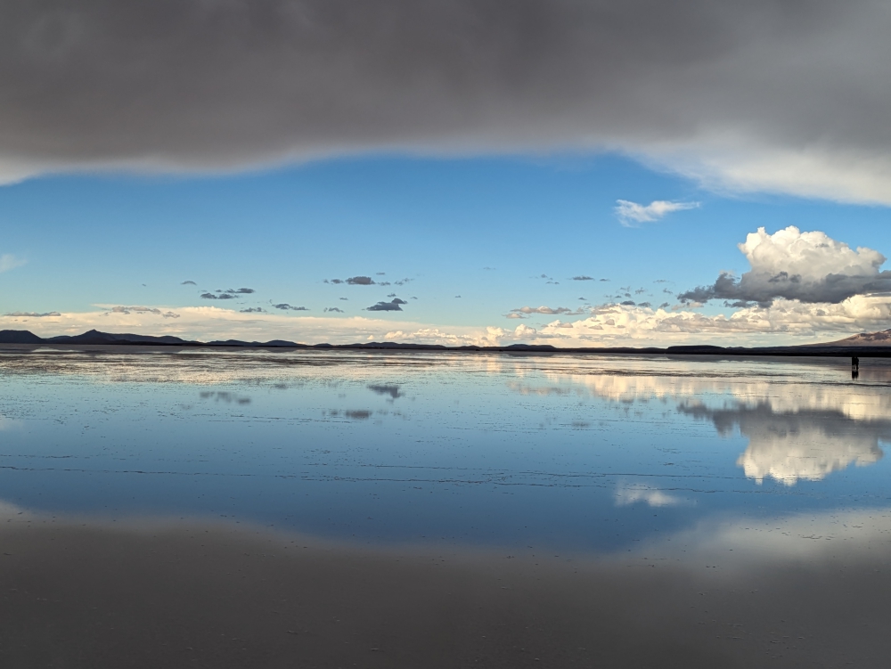
Reflection pool on the salt flat

With that in mind, Mark, Maya, and I booked a tour for the day. Even better, we arranged a private excursion for our little family to give Maya (who was recovering from a nasty dog bite) enough comfort and space, and to allow us the privacy and freedom of a trip tailored to just the three of us. We could tell our guide wherever we wanted to go on the Salar, what to skip or limit, and whenever we wanted to move on. And, to be honest, at twice the price of a group tour ($120 for the three of us instead of $60), we believed it was worth the splurge. 😊

Our tour started at 10:30am, would finish after sunset, around 8pm, and included lunch and drinks. We decided to skip stop one (the Train Cemetery where we had been living, exploring, and photographing for four days already) and made stop two (salt processing tour and artisanal markets) shorter, for an earlier start on the Salar. A massive rain storm was threatening, so I wanted to stay ahead of that!

Once on the salt flat, the fun could begin! We stopped by the Ojos de Agua, which our Spanish-speaking guide, Eusevio, called the “breath” of the Salar. Water bubbled up from below, as if something was breathing under the surface.

He encouraged us to employ a local guy to take “forced perspective” photos of us and Maya. Since that was affordable, we obliged.

Continue reading

The Tatacoa Desert – A Unique & Peaceful Ecosystem in Colombia

Despite its famed high temperatures, Mark and I were looking forward to visiting the Tatacoa Desert after leaving Bogota. This off-road adventure promised to bring us peace, beauty, and remoteness. The only problem: our recently punctured and fixed tire. Would it hold up on the bumpy, challenging roads?

(As always, hover over or click on photos in galleries to read their captions.)

Getting to the start of the desert loop was exciting in itself. After a couple of toll roads, road construction delays, another landslide hold-up, a police checkup, a small town, and narrow dirt roads, Thirsty Bella had to cross a narrow, 100-year-old railroad bridge and traverse two windy, one-way tunnels where opposing traffic was not visible. We kept our fingers crossed when entering these dark, water-filled passageways and, once inside, honked and flickered our headlights for good measure. We made it okay! It took us an entire day to drive from Silvania to Tatacoa.

This desert area in Colombia is relatively small, yet, we hoped to stay a handful of days because we craved peace, solitude, and relaxation.

Sign at the beginning of the loop (north side)

Continue reading

A Scenic Highlight in Colombia – Volcano Nevado del Ruiz & Hot Springs (A Photo Blog)

In the middle of March, our trio decided to head south and then east from Jerico, high into the mountains, to visit natural hot springs… The road was long, windy, and not without obstacles, but our biggest disappointment was arriving at our camping spot in the rain, with no visibility.

(Hover over or click on photos in galleries to read their captions.)

But we woke up with this: blue skies and a view of our surroundings.

Imagine our surprise when we spotted this snow-covered volcano on our early morning walk with Maya.

We had to do a double-take!

At 7am and at an elevation of over 13,000 ft (4,000m), it was cold!

The flora was interesting as well.

I was enamored by all the flowers that bloomed at this altitude.

We couldn’t get enough of this view – Can you see Thirsty Bella?

The other side of the valley. Clouds started to roll in again.

After our morning walk and breakfast, we drove to El Sifon hot springs. It wasn’t even 9am yet and the volcano was already covered by clouds, with fog starting to roll in. But the first few miles were still photogenic, with lots of waterfalls along the road.

Where is the trail?

We managed to find a dirt road at some point and descended about 1,000ft towards the river and the natural hot springs.

We had the area to ourselves!

We found our spot: under the two waterfalls was a small pool.

This was a very scenic area, despite the steam.

After our soak – the contrast between the water and air temperature was huge!

One last shot of El Sifon hot springs!

Then, the walk back up was inevitable. It took forever, since the air was thin and we needed to stop often to catch our breath, especially me.

Back at the parking lot, life went on as always.

On our second morning, I encouraged Mark to take a photo of me and my book, Plunge, in front of the volcano…

That’s when we noticed a slight change in the appearance of Nevado del Ruiz…

Most of the snow had melted and it was spewing steam!

The photos underneath were taken around the same time, early in the morning, two days in a row. Do you notice the difference in the volcano’s appearance?

Mark took this fabulous shot.

Mark, Maya, and I came here in our truck camper Thirsty Bella to check out the hot springs and we received these spectacular views as a bonus! It was one of the quietest places we camped in Colombia. We did have to leave after two nights, though, because it was difficult to sleep and breathe at 13,000ft (4,000m) altitude and the condensation inside the camper was so bad that water kept dripping down from the ceiling!

(A week later, people from the surrounding villages had to be evacuated because of the heightened risk of a volcanic eruption and access to this area became restricted. Until now, nothing dangerous has happened. Read a CNN article here.)

360-degree view on our morning walks with Maya

Curious about a previous ten-year chapter in our nomadic lives, which includes eight years aboard a 35-foot sailboat in the tropics with dogs, check out my compelling, inspiring, and refreshingly honest travel memoir:

Plunge – One Woman’s Pursuit of a Life Less Ordinary

Available on Amazon and elsewhere

eBook: US$ 5.99

Paperback: US$ 13.99

A Trio of Quaint Historic Towns in Colombia – Santa Fe de Antioquia, Jericó, and Jardín (Our All-time Favorite)

All three towns have been declared pueblos patrimonios in Colombia (because they stand out for their cultural heritage) and are worth a visit. Medellin is centrally located for attractive day or weekend trips to these destinations in the Department of Antioquia. Or, in our case, for continued travels to explore Colombia. A fourth highlight, Guatapé, sits two hours east and was part of my Medellin post. Santa Fe de Antioquia can be found an hour and a half to the northwest. You reach Jericó after a three-hour southward drive and Jardin is a tad further away, about 3.5 hours to the south.

Historic towns around Medellin

Santa Fe de Antioquia

As a former capital of Colombia and a national monument, Santa Fe de Antioquia is a popular place. It is a beautiful, eye-catching, and photogenic city of 23,000 inhabitants. But there is one problem. For us anyway. Its climate is tropical and humid, due to its low elevation in the Cauca River valley and proximity to the equator. It was in the mid-nineties when we arrived (35°C)!

(As always hover over or click on photos in galleries to read their captions.)

Our first “meeting” with the town didn’t go well. Checking the map for the best route to a free overnight parking spot we had found in our free app iOverlander, we’d picked a one-way road towards our site, thinking it would be wide enough and less littered with haphazardly parked cars. We were right, but… the road went steep uphill and, without any indication, was blocked by road work! We couldn’t go around it. We couldn’t turn around. We couldn’t back up, down this steep and bumpy road without visibility. All the while, motorcycles kept passing us (they could go through) and lined-up cars behind us kept honking.

I enabled a neighbor’s help to open the locked gate of his driveway and guided Mark to safely turn around. We headed back the way we came and my husband was ready to abandon our planned visit. I persisted. We were all sweating (and panting), there was no shade anywhere, and options to camp were limited. On foot, I checked out a parqueadero (parking lot) that abutted the historic center. Big buses and trucks were parked there, so we would fit. We just needed to navigate one more narrow road. Mark obliged and we hid inside our camper, fans on full speed, for the rest of the afternoon.

When the temperature dropped slightly and darkness set in, the three of us quickly walked through the center of town. Unfortunately, the moods didn’t improve. Being kept awake all night by arriving and departing buses, garbage trucks, and dump trucks didn’t help the situation by morning. Mark had had it with this place, so I ventured back into the historic part early and for just one hour. Then, we moved on. Did I mention it was Mark’s birthday?

Continue reading

A Glimpse of Medellin and Its Surroundings – One of Colombia’s Most Popular Destinations

Before experiencing Medellin and environs, we first had to get there – and find places to camp! After our little adventure in Florián, we had a long drive, not so much in miles as in time and bad roads.

“Isn’t Colombia famous for its toll roads,” you ask. I would think so, based on the number of them – and they’re pricey relative to local standards. Yet, nobody talks about them. The main reason I mention toll roads here, however, is because some most of them suck. At least north and east of Medellin. They contain potholes, speed bumps, shifted tarmac, wide cracks, dips, and gaps – and you have the privilege to pay for hitting the obstacles. Hard. Because, you know, the speed limit is all of a sudden much higher on these “highways.”

That is my long-winded way to say that we hit a pothole really, really badly. Neither of us had seen it – I had my eyes on my tablet writing a message (since we were on a smooth toll road, right?) and Mark was staring at the navigation screen to check a potential turn-off.

At the time, we only discovered that the backside of our camper (a structural problem we thought we’d fixed in the US) had become separated again, something we had to fix ASAP. Later, we discovered other issues with the truck as a result of this mistake and the massive impact of the camper and truck bed colliding. From then on, it has been ALL eyes on the road ALL the time…

It took us two days and a loud night along the “highway,” before we reached Rio Claro. We hoped to relax here for a few days, visit a national park, and enjoy swimming in the clear river as – at this low elevation – it was quite hot and humid. We’d quickly stopped at Hacienda Napoles as well, known from Pablo Escobar movies and documentaries. It was closed that day – and expensive, so we’d pass anyway.

We arrived at a recommended campsite along the Rio Claro river around 5pm and took a refreshing swim and cold outdoor shower. Then, I had a translation job. But the cell service was very hit or miss and it took me hours to make little progress.

That night, a huge thunder and lightning storm arrived (which had Maya hiding behind our pillows again). In the morning, the river had turned brown and the internet remained elusive. We drove a few hours to a mirador (viewpoint) in the mountains, where I had to work against the clock to get the assignment finished. Talk about stress. A loud and sleepless night followed.

Our long-anticipated destination

Mark, Maya, and I were excited to finally meet Susan and John in person. It was a long time coming. Expats in Colombia, their lifestyle and travels (in country and abroad) had always intrigued me and I’d been following their blog Latitude Adjustment for many years. When they moved from Medellin to El Retiro a couple of years ago, it all sounded so nice that I wanted to check out their town as well.

Continue reading

Another Off-road Adventure in the Mountains of Colombia — The Waterfalls & Cave of Elusive Florián

After enjoying Villa de Leyva, the end of January, the plan was to embark on another off-the-beaten-track adventure. But, as we wrapped up an extended stay in our favorite Colombian pueblo patrimonio, we faced two possible issues: the weather forecast predicted rain which could make the dirt roads impassable and we were on a deadline, because we wanted to visit our friends Susan and John in El Retiro for a handful of days, before they’d leave on a trip in the middle of February and would have other guests prior to that. Plus, we were in the midst of dealing with a vehicle extension and didn’t know if this would require a last-minute stop in Medellin.

Tiered waterfalls in Florián

Could we fit in a multiple-day side trip to Florián without encountering muddy roads, would the challenging detour be worthwhile, and would we have enough time left to make the two-day drive and visit Rio Claro on the way to El Retiro?

Few Colombians have heard of Florián, located in the middle of the mountains of the Santander department. Wikipedia in English doesn’t have much info but the Spanish page has a bit more data. The town is known for its multi-tiered waterfall, which tumbles out of a cave. It sounded cool but would take us a full day to reach; the last four hours over bouncy, slow, dirt roads.

(As always, hover over or click on photos in galleries to read their captions.)

Mark stumbled across this destination a few months ago, probably seeing photos by a fellow overlander on Facebook. He pinned it in Google maps, which is how we now compile lists of worthwhile destinations. And, by reading in our fat South America Lonely Planet.

When we arrived, exhausted and shaken, we parked along the main square for the night. We walked around town and to a viewpoint of the valley, wondering where the waterfall was located. We surely thought we’d have seen – if not heard – it by now. That’s when we discovered there was nothing but a trickle, none of it visible from a distance. To say we were disappointment is an understatement!

Continue reading

Why We Love Villa de Leyva, Colombia – Camped for a Week in This Picturesque Colonial Village

After a long day on the road with the necessary stress and quarrels, I was in a bad mood when Thirsty Bella rolled into Villa de Leyva, located in the Colombian department of Boyacá. We pulled into a free parking lot, which in my mind would be level, covered in soft grass, and sprinkled with fellow overlanders. I looked forward to finally sitting outside in our camping chairs and having a chat with like-minded travelers, since this town is on the tourist map.

(Click on or hover over photos in galleries to read their captions.)

In reality, it took us a while to get relatively level on our wooden boards, nobody else was there, the green from the photos were poky weeds, and I got eaten alive by nasty no-see-ums in the process of getting settled. Tons of bumpy bites erupted; they would itch for weeks. Never have expectations!

Walking towards town along the tree-lined parking lot

Luckily, once we strolled over the cobblestones and towards the enormous square for the first time, despite wearing flipflops (note to self: sturdy shoes required), we fell in love with this clean, attractive, and historic town. We stayed the entire last week of January, catching up on internet work and exploring Villa and surroundings. The climate was perfect and hiking opportunities abound, but the following are the main reasons for our fondness of this pueblo patrimonio.

Our camping spot

Thanks to our free app iOverlander, we zoomed in on this free parking spot along the edge of town, moving once to get more sun on our solar panels. We had plenty of space around us and as long as we didn’t spend much time outside in this bug-populated field, all was good. We soon learned to constantly wear long clothes and socks and shoes. Against the biting insects and to avoid sprained ankles on the cobblestones.

Our location was perfect to experience this wonderful village and to make us feel like locals. It was a two-minute walk to a dumpster, mere seconds to visit a hairdresser ($6), the main square was situated about five minutes away, as well as a plethora of restaurants, our favorite bakery needed ten minutes to be reached, and we could fill our tanks with spring water for free a couple of blocks away. Donations are encouraged.

When we topped up again before leaving, a parked car caused us to round one corner a tad too wide. The ladder of our camper took some rooftiles down. We stopped, talked to the owners of the gate, and reimbursed them the $20 worth in damage.

The streets

Continue reading

Thursday Doors – In Picturesque, Free-spirited, and Historic Bisbee, Arizona

About a year and a half ago, Mark and I (and our friends Duwan and Greg) visited Bisbee in southeastern Arizona. Other than sightseeing and getting a good feel for this historic town’s vibe, we looked at houses for sale. Yes, there was a time that we might have gotten serious about the prospect of owning a “real” home. But, us being wandering spirits, picky, and frugal made us pass on Bisbee, a town we enjoyed exploring. I blogged about those impressions and experiences here.

(As always, hover over or click on photos in galleries to read their captions.)

It was in this picturesque town that I took a few photos of doors, thinking that, one day, I would join the Thursday Doors blog hop. Yeah, sometimes it takes me a while to follow up on thoughts and ideas. 🙂

Continue reading

Ten Days at a Pebble Beach in Baja – Friends, Wildlife, Hikes, and Views

Our arrival in Baja California, Mexico, was delayed by six weeks, because we decided to work for a month in the Phoenix area (Arizona, USA) after spending more money than anticipated on the cross-country drive from east to west. We also had a few important phone calls requiring unwavering internet and we needed an extra two weeks to prep our camper for the trip.

The majestic Sea of Cortez

Soon after crossing the border in mid-January, we decided Mark should fly back to Massachusetts for a family matter. To accommodate that impromptu trip, we “rushed” south on the peninsula and prepared for his imminent return. Maya and I stayed at a campground in Loreto (Rivera Del Mar) during his ten-day absence.

(As always, hover over or click on the photos to read their captions.)

After all those arrangements and adjustements, you can imagine that we were more than ready and excited to take “a break from life” and start our Baja adventures. On February 1st, we filled our truck camper, T&T, with drinking water, propane, and food, emptied our sewage tanks at the campground, and headed south for a beach vacation along the Sea of Cortez. We spent one night at Juncalito Beach to get a decent start the next morning. The road to our destination in the Agua Verde area would be slow, treacherous, and mind blowing; a perfect introduction to Baja’s roughness and beauty.

As expected, the single-track dirt road contained sharp turns, potholes, small rocks, and gravel. Some parts were steep and nerves of steel were required. Mark did a great job bringing us down to the coastline, where the track turned into the usual Baja secondary road: washboard, sand, and gravel. The cloudy, drizzly weather was unusual.

Continue reading

Five Things to Do in Loreto, Baja California, Mexico

Mark, Maya, and I visited Loreto for a few days last year, in our campervan Zesty. It was pretty much our most southern stop on the peninsula during a two-month Baja California sojourn. We spent most of that time on the beaches of Bahia Concepcion and in Mulege, a town we liked better than Loreto. I wrote about that “comparison” here.

Every city in Baja California has a statue of their name in colorful letters.

When it became clear and imminent for Mark to fly back to Massachusetts last month, we decided Loreto would be the best, most convenient, and cheapest place for Maya and me to await his return. We managed to snag a “dry camping” spot at Rivera del Mer RV Park ($5/person/night), which has splendid bathroom and laundry facilities.

Vendors with fresh tortillas and other goodies pass right by the gate and the center of town is a short walk away. Unless you have a dog. That requires a detour to avoid all the barking, aggressive, local canines guarding their properties.

Lunch on fresh corn tortillas, bought from a passing vendor

(As always, hover over or click on the photos to read their captions.)

Here are my five highlights of Loreto, which grew on me when I camped there in T&T the last twelve days of January.

Seal on the pedestrian walkway in town

Continue reading
Older posts

© 2024 Roaming About

Theme by Anders NorenUp ↑