Roaming About

A Life Less Ordinary

Tag: sightseeing (page 1 of 6)

The Sacred Valley in Peru – As Overlanders

After two weeks in Cusco, doing camper projects, running errands, being sick, and exploring the historic center, our plans turned a bit tricky. My cousin and her husband, perfect guests who visited us frequently when we sailed in the tropics, had booked plane tickets to join us in the Cusco area for two weeks, towards the end of November, following a two-week bus tour through Southern Peru. Nothing tricky about that, except for the fact that our immigration stamps expired the end of October…

Based on accounts from other overlanders, we believed we had a good chance to obtain another sixty days in Peru, at the border with Bolivia; an ordeal we’d have to figure out later and something I worried about for over a month. It was mid-October now and we had two weeks left in the country.

We expected to visit the Sacred Valley with my family, but what if we wouldn’t be allowed back into Peru? Were we willing to miss out on this country’s highlights, like Machu Picchu, Arequipa, and the villages and archeological sites in the Valle Segrado?

Mark and I opted for an in-between solution: we skipped famous Machu Picchu (expensive and a hassle to get to) – for now – and bought a two-day tourist ticket for 70 soles/$20 each to visit the highlights of the Sacred Valley. This would be a different way of traveling for us, who usually take it slowly, camping wherever it looks attractive. We had two days to explore five sites and two historic villages!

Pisac archeological site

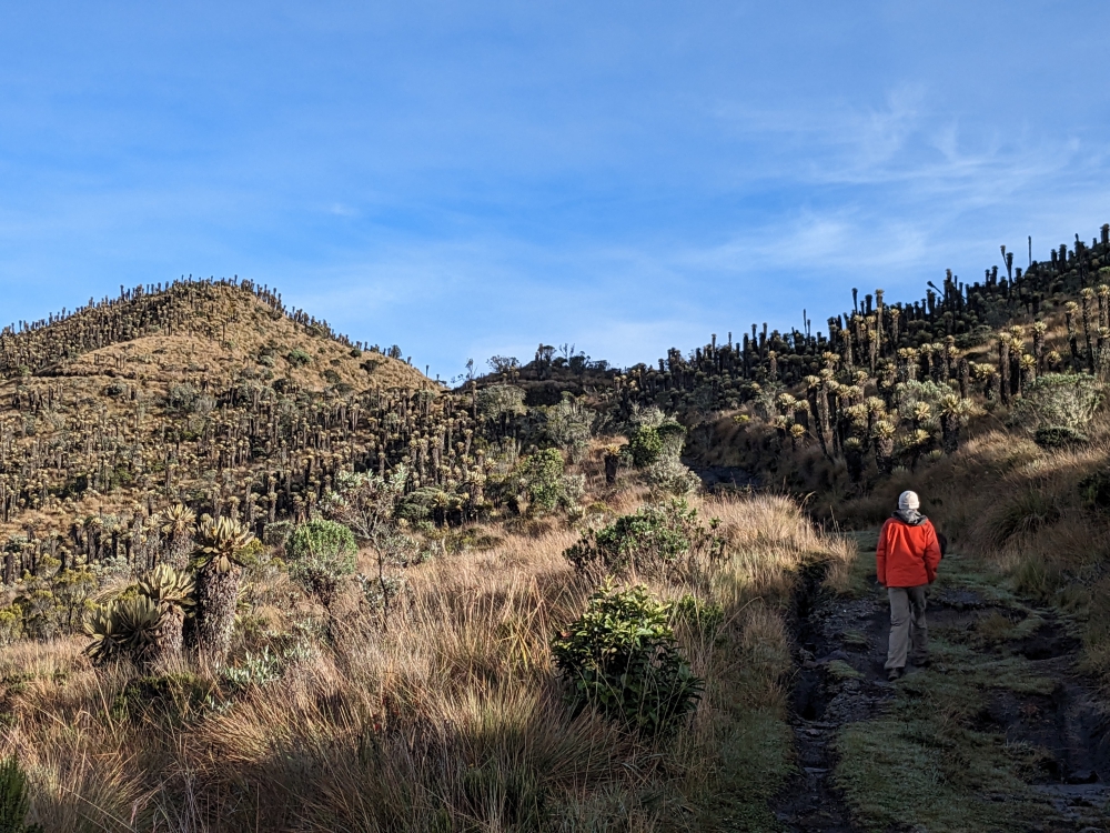
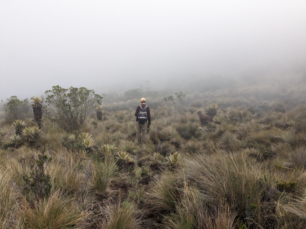
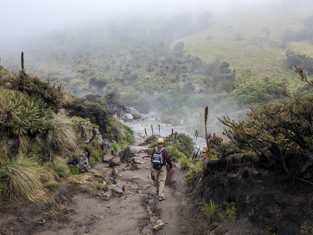
From the Cusco campground, we headed uphill, past the trio of ruins we’d checked out previously, via a viewpoint that offered potable water from a spigot, to a pull-out along a quiet road for the night. The following morning, we descended into the valley and spotted the famous terraced hills of Pisac.

Traveling with a camper makes it easy to leave our dog behind, in a cool and shady environment with plenty of water. Mark and I braved the long climb to the citadel, breathing heavily in the thin air and taking many breaks.

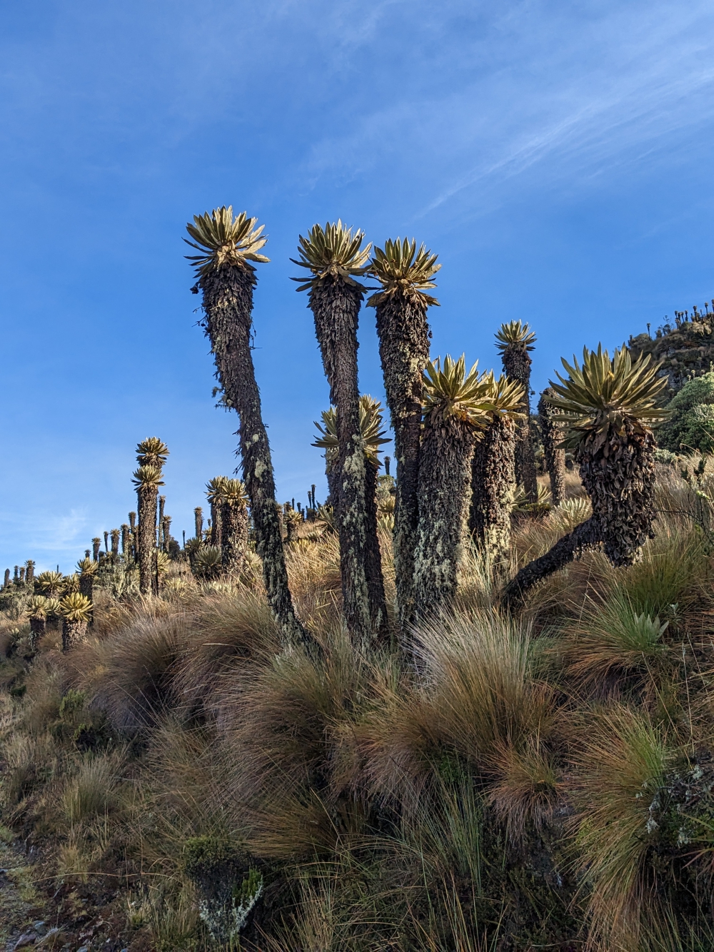
The Pisac archeological site is a large Incan complex of agricultural terraces, residences, guard posts, watchtowers, and a ceremonial center along a mountain ridge above the town of the same name. It was built around 1440.

Little is known about the site’s actual purpose. Researchers believe that old Pisac defended the southern entrance to the Sacred Valley and was an observatory and religious site.

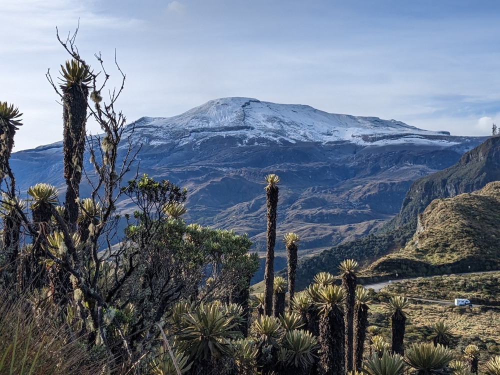
The best way to explore this destination is by taking a taxi or minibus to the entrance, climbing the hill, and then following a path down to Pisac town. Since we had our vehicle with us, we only visited the top part of this impressive site.
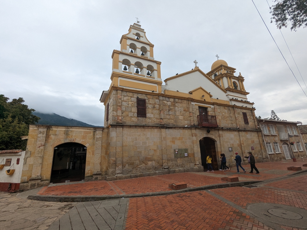
Pisac town

Continue reading

Overlanding in the Cordillera Blanca, Peru – Rough Roads and Splendid Scenery

From the sleepy fishing village of Tortugas, Mark, Maya, and I headed inland again, back to the Andes Mountains. After traveling around Northern Peru for three weeks in our truck camper Thirsty Bella, our first impressions of the country had not been positive. Fellow overlanders kept telling us “It would get better further south.” We were both looking forward to “better,” “prettier,” and, above all, “quieter.”

Map of our sights in the Cordillera Blanca

Huaraz

We drove from sea level to 14,000ft (4,200m) in one day, so, as you can imagine, the scenery changed drastically as we climbed from littered roads and uninspiring plots of dirt to green fields, pine trees, and, above the tree line, views of the impressive snowy peaks of the Cordillera Blanca.

(As always, hover over or click on photos in galleries to read their captions.)

On our first night in the hectic town of Huaraz, we decided to camp at its viewpoint (11,000ft or 3,350m) for a more peaceful experience. We failed to learn that the road up was narrow, rocky, and stressful. I can’t say the view was that special, but we did, at least and at last and despite a vague headache, have a quiet night – after trying to level up a bit, getting dressed for and dealing with a police visit at 11pm, and meeting expat and missionary Larry, who thought it was a good idea to scream “Good morning, Liesbet and Mark” on his 5am run the following day.

Continue reading

Two Enjoyable Cities & Inca Ruins in Southern Ecuador – Cuenca, Vilcabamba, and Ingapirca

When the middle of July arrived, Mark and I found ourselves with only two weeks left in Ecuador, before our allotted three-month entry stamp expired (August 2nd). By then, we had long decided to skip the jungle region and, more recently, the coast as well. For months, we had looked forward to visiting the beaches of Montanita, watching the sunset, having happy hour with our toes in the sand, and letting Maya frolic in the sea. But it would be a major detour and – as we were about to head that way – police officers, knocking on our door at 6am near Cotopaxi Volcano, talked us out of it. Drug-related crime and petty theft seem to fester along the Ecuadorian coast.

View towards the Temple of the Sun at Ingapirca

Ingapirca – Our First Inca Ruins

The three of us kept heading south after spotting the snowy peak of Volcano Chimborazo (I added a cool photo to my last Ecuador post of my friend Marie on top of the world – and closest to the sun – after scaling Chimborazo) and aimed for the Inca Ruins of Ingapirca.

Marie on the top of Chimborazo at sunrise
Photo credit Marie Fraisse

It was a long drive, involving a massive detour over bumpy roads around and through the town of Alousi, due to a massive landslide and subsequent road works. The scenery was stunning!

(As always, hover over or click on photos in galleries to read their captions.)

We arrived at our destination late afternoon, so the parking lot was pretty full and we took a temporary, unlevel spot, while checking out the neighborhood with Maya. Once a level space became available, we moved and settled in for the night. We’d visit the ruins in the morning, thinking we would stay for two nights. But, since the parking lot was actually straddling a busy road and residents love to ride their loud motorcycles with 2-stroke engines, we decided to not face a second sleepless night.

Parking lot of the Ingapirca ruins, early morning

This relatively small site packed a punch for us, because it was our introduction to the Inca empire and culture. Tickets only cost US$2 per person and include a guide. Maya stayed home for this one. We booked the first tour of the day at 9:15am and enjoyed the different areas and English explanations of our excellent and passionate guide, Segundo.

We learned a lot about the Incas and their predecessors, the Cañaris, whose building practices the Incas only integrated here at Ingapirca, Southern Ecuador. Both groups used different kinds of stones, visible at this site. The Cañaris utilized round river rocks and the Incas cut, rectangular blocks. This is the only Inca site in the world with a temple (Temple of the Sun – Templo del Sol) that has round walls, because of the influence of the Cañaris.

After the hour-long tour, Mark and I finished exploring the region with a self-guided walk past smaller sites and through nature. It was super quiet and we had to work around sprinklers in the fields to avoid getting soaked.

Continue reading

Volcanos and Waterfalls in Central Ecuador – Cotopaxi, Chimborazo, Quilotoa, and Baños

After Mark, Maya, and I finished our car projects and left the comfortable and safe haven of friend Graham’s driveway in Ibarra, we only had four weeks left to explore the central and southern part of Ecuador, before our three-month visas expired. We hadn’t gotten very far yet, after two months!

Our visited sites in Central Ecuador

Cotopaxi Volcano

We drove a bunch to pick up our trail from a month prior, south of Quito, the country’s capital. Our first stop was the impressive Cotopaxi volcano, which is often hiding in the frequent clouds at this altitude.

Thanks to our free iOverlander app, we found a peaceful wild camping spot near the national park. We failed to see the mountain, but we persevered, spending two nights at 12,000ft (3,650m) without internet, walking Maya in the paramo, meeting wild horses, running our heater at night, and waiting for a glimpse.

On our second evening, after the sun set, we spotted Cotopaxi’s snowy top. The light was not ideal for optimal viewing or photography. We crossed our fingers for a clear morning the following day as, unfortunately, we couldn’t stay longer due to the lack of cell service.

And, look what we woke up to on day three! Time for photo shoots – and to drive into the national park for an up-close view and feel of Cotopaxi!

Since dogs are technically not allowed in Ecuadorian national parks (which are free), Maya stayed in the car and camper during our visit. We first drove to a small lake with decent views.

Then, our heavy vehicle managed to climb the volcano itself, to the parking lot at 15,000ft (4,570m), from where visitors can ascend the mountain to a glacier and refugio (shelter/restaurant). It is possible to climb further to the top with a guide. As you can imagine, the air was thin here and putting one foot in front of the other laborious. Mark made it “up there,” but I had to turn around when dizziness and a serious headache threatened.

Quilotoa Lagoon

Quilotoa has been a highlight for many visitors to Ecuador, so we had to check it out. The road to the small town with the same name was paved and pretty, but realizing that hundreds of homeless, starving dogs are being dumped and now linger along this “highway” was heart-breaking.

Continue reading

Colombia’s Capital and Surroundings – Historic Bogota, Camper Work in Cota, Cute Guatavita, the Salt Cathedral in Zipaquira & Tire Terrorists in Soacha

The drive from the Cocora Valley to the nation’s capital was long. We had an early start but due to road, traffic, and weather conditions, we didn’t arrive in Cota until 6:30pm. We hate driving in the dark, especially when rain is present, but sometimes there is no choice. We needed to reach a decent stop for the night. Mark finished our trip slowly and carefully and I kept my teeth clenched.

Approaching Bogota and Cota after dusk

The day started out okay, with toll roads that actually were worth paying for and tons of amazing tunnels through the mountains. They depicted animal names with pictures, so we learned a thing or two. La Linea is the longest tunnel in the Americas. And there were donkeys!

(As always, hover over or click on photos in galleries to read their captions.)

As the hours and the scenery passed by, we reached the congested suburbs with deteriorating roads. We had to top up our propane tank, so that was a rush against the clock as the place closed at 5pm. We made it but were surprised to find this business in an industrial area with crowded, potholed, dirt roads. When we left with a full tank, the attendant asked if we wanted to take a puppy. They had one on their property and didn’t know what to do with it. We declined, heart-broken, as we listened to the yelps of the pup.

Church in Cota

Cota

The reason we decided to base ourselves in Cota, a “suburb” northwest of Bogota, was because we knew a helpful Colombian there, Juan from Overland Sally, who’d be able to assist with whatever we required. We had some projects to take care of, one of which was building a wooden platform to raise our camper a bit (after Bella’s overhang in the front banged onto the truck’s cab roof when driving down a bumpy hill one day).

Continue reading

A Scenic Highlight in Colombia – Volcano Nevado del Ruiz & Hot Springs (A Photo Blog)

In the middle of March, our trio decided to head south and then east from Jerico, high into the mountains, to visit natural hot springs… The road was long, windy, and not without obstacles, but our biggest disappointment was arriving at our camping spot in the rain, with no visibility.

(Hover over or click on photos in galleries to read their captions.)

But we woke up with this: blue skies and a view of our surroundings.

Imagine our surprise when we spotted this snow-covered volcano on our early morning walk with Maya.

We had to do a double-take!

At 7am and at an elevation of over 13,000 ft (4,000m), it was cold!

The flora was interesting as well.

I was enamored by all the flowers that bloomed at this altitude.

We couldn’t get enough of this view – Can you see Thirsty Bella?

The other side of the valley. Clouds started to roll in again.

After our morning walk and breakfast, we drove to El Sifon hot springs. It wasn’t even 9am yet and the volcano was already covered by clouds, with fog starting to roll in. But the first few miles were still photogenic, with lots of waterfalls along the road.

Where is the trail?

We managed to find a dirt road at some point and descended about 1,000ft towards the river and the natural hot springs.

We had the area to ourselves!

We found our spot: under the two waterfalls was a small pool.

This was a very scenic area, despite the steam.

After our soak – the contrast between the water and air temperature was huge!

One last shot of El Sifon hot springs!

Then, the walk back up was inevitable. It took forever, since the air was thin and we needed to stop often to catch our breath, especially me.

Back at the parking lot, life went on as always.

On our second morning, I encouraged Mark to take a photo of me and my book, Plunge, in front of the volcano…

That’s when we noticed a slight change in the appearance of Nevado del Ruiz…

Most of the snow had melted and it was spewing steam!

The photos underneath were taken around the same time, early in the morning, two days in a row. Do you notice the difference in the volcano’s appearance?

Mark took this fabulous shot.

Mark, Maya, and I came here in our truck camper Thirsty Bella to check out the hot springs and we received these spectacular views as a bonus! It was one of the quietest places we camped in Colombia. We did have to leave after two nights, though, because it was difficult to sleep and breathe at 13,000ft (4,000m) altitude and the condensation inside the camper was so bad that water kept dripping down from the ceiling!

(A week later, people from the surrounding villages had to be evacuated because of the heightened risk of a volcanic eruption and access to this area became restricted. Until now, nothing dangerous has happened. Read a CNN article here.)

360-degree view on our morning walks with Maya

Curious about a previous ten-year chapter in our nomadic lives, which includes eight years aboard a 35-foot sailboat in the tropics with dogs, check out my compelling, inspiring, and refreshingly honest travel memoir:

Plunge – One Woman’s Pursuit of a Life Less Ordinary

Available on Amazon and elsewhere

eBook: US$ 5.99

Paperback: US$ 13.99

A Trio of Quaint Historic Towns in Colombia – Santa Fe de Antioquia, Jericó, and Jardín (Our All-time Favorite)

All three towns have been declared pueblos patrimonios in Colombia (because they stand out for their cultural heritage) and are worth a visit. Medellin is centrally located for attractive day or weekend trips to these destinations in the Department of Antioquia. Or, in our case, for continued travels to explore Colombia. A fourth highlight, Guatapé, sits two hours east and was part of my Medellin post. Santa Fe de Antioquia can be found an hour and a half to the northwest. You reach Jericó after a three-hour southward drive and Jardin is a tad further away, about 3.5 hours to the south.

Historic towns around Medellin

Santa Fe de Antioquia

As a former capital of Colombia and a national monument, Santa Fe de Antioquia is a popular place. It is a beautiful, eye-catching, and photogenic city of 23,000 inhabitants. But there is one problem. For us anyway. Its climate is tropical and humid, due to its low elevation in the Cauca River valley and proximity to the equator. It was in the mid-nineties when we arrived (35°C)!

(As always hover over or click on photos in galleries to read their captions.)

Our first “meeting” with the town didn’t go well. Checking the map for the best route to a free overnight parking spot we had found in our free app iOverlander, we’d picked a one-way road towards our site, thinking it would be wide enough and less littered with haphazardly parked cars. We were right, but… the road went steep uphill and, without any indication, was blocked by road work! We couldn’t go around it. We couldn’t turn around. We couldn’t back up, down this steep and bumpy road without visibility. All the while, motorcycles kept passing us (they could go through) and lined-up cars behind us kept honking.

I enabled a neighbor’s help to open the locked gate of his driveway and guided Mark to safely turn around. We headed back the way we came and my husband was ready to abandon our planned visit. I persisted. We were all sweating (and panting), there was no shade anywhere, and options to camp were limited. On foot, I checked out a parqueadero (parking lot) that abutted the historic center. Big buses and trucks were parked there, so we would fit. We just needed to navigate one more narrow road. Mark obliged and we hid inside our camper, fans on full speed, for the rest of the afternoon.

When the temperature dropped slightly and darkness set in, the three of us quickly walked through the center of town. Unfortunately, the moods didn’t improve. Being kept awake all night by arriving and departing buses, garbage trucks, and dump trucks didn’t help the situation by morning. Mark had had it with this place, so I ventured back into the historic part early and for just one hour. Then, we moved on. Did I mention it was Mark’s birthday?

Continue reading

Escape into Nature – Mount St. Helens National Volcanic Monument in Washington State

I hinted at it before: Mark and I have had some challenges the last few months, in general, and a few difficulties and issues regarding our current Lance 830 truck camper. Without going into detail just yet, we decided that our best plan of action in early July (a week before my departure to Belgium) was to head into the woods. We could use a change of scenery, needed to escape the 90+ temperatures of Portland, Oregon, wanted to test our camper on rough roads and terrain, and looked forward to camping in nature again.

(As always, click on or hover over the photos in galleries to read their captions.)

The three of us had a fantastic time hiking in Mount St. Helens National Volcanic Monument, sleeping in the Gifford Pinchot National Forest, exploring trails and backroads, and bouncing around on the roughest roads we ever encountered (since that was the goal).

Continue reading

Wet & Wild Mesquite Canyon – One of the Most Spectacular Hikes in Baja California Sur, Mexico

A hike in Mesquite Canyon, located about an hour south of Loreto, Baja California Sur, Mexico, was on the agenda last year, especially after seeing photos about it on our friends Sandie and Karsten’s blog. They had told us how to get there, but our mistake was not writing down the instructions and neglecting to search for the approach on Google Map’s satellite image.

Hiking in the heat to find the trail last year – in vain

We found the correct entrance road in the spring of 2021, drove through the gravel pit area, parked, and explored two approaches on foot with Maya. One brought us to a gate, which we didn’t think allowed public access (it did) and the other gravel path brought us into the mountains after a couple of hot and rocky miles, before we believed this wasn’t right.

The gate was closed last year, so we didn’t proceed. The trail starts two miles past this point.

It was late afternoon by the time we returned to Zesty, so we spent the night in the peaceful environs of a gravel pit. Bummed, we gave up on this alleged incredible canyon hike. When we saw Sandie and Karsten again, they mentioned the trail started two miles past the gate.

Camped with Zesty near the gravel pit, last year

Needless to say, this hike in Mesquite Canyon was high on the list during our recent return trip to Baja California Sur. This time, we did enough research and were determined to find the trail. Except, it was Sunday and the access road to the canyon was blocked off. Despair and disappointment arrived.

Oh no, the access road is blocked!

Continue reading

Ten Days at a Pebble Beach in Baja – Friends, Wildlife, Hikes, and Views

Our arrival in Baja California, Mexico, was delayed by six weeks, because we decided to work for a month in the Phoenix area (Arizona, USA) after spending more money than anticipated on the cross-country drive from east to west. We also had a few important phone calls requiring unwavering internet and we needed an extra two weeks to prep our camper for the trip.

The majestic Sea of Cortez

Soon after crossing the border in mid-January, we decided Mark should fly back to Massachusetts for a family matter. To accommodate that impromptu trip, we “rushed” south on the peninsula and prepared for his imminent return. Maya and I stayed at a campground in Loreto (Rivera Del Mar) during his ten-day absence.

(As always, hover over or click on the photos to read their captions.)

After all those arrangements and adjustements, you can imagine that we were more than ready and excited to take “a break from life” and start our Baja adventures. On February 1st, we filled our truck camper, T&T, with drinking water, propane, and food, emptied our sewage tanks at the campground, and headed south for a beach vacation along the Sea of Cortez. We spent one night at Juncalito Beach to get a decent start the next morning. The road to our destination in the Agua Verde area would be slow, treacherous, and mind blowing; a perfect introduction to Baja’s roughness and beauty.

As expected, the single-track dirt road contained sharp turns, potholes, small rocks, and gravel. Some parts were steep and nerves of steel were required. Mark did a great job bringing us down to the coastline, where the track turned into the usual Baja secondary road: washboard, sand, and gravel. The cloudy, drizzly weather was unusual.

Continue reading
Older posts

© 2024 Roaming About

Theme by Anders NorenUp ↑